|
|
|
|||||||||
|
–Ъ–ї—Г–± –ї—О–±–Є—В–µ–ї–µ–є –≤–љ–µ–і–Њ—А–Њ–ґ–љ—Л—Е –њ—Г—В–µ—И–µ—Б—В–≤–Є–є. |
search must be here | |||||||||
| –°—В–∞—В—М–Є :: –Ш–љ—Б—В—А—Г–Ї—Ж–Є—П –і–ї—П Ozi Explorer | ||||||||||

| |
| |
| |
| |
| |
| |
| |
[phpBB Debug] PHP Warning: in file /var/www/sites/4x4typ/engine/common.php on line 262: fgets() expects parameter 1 to be resource, boolean given
–Ш–љ—Б—В—А—Г–Ї—Ж–Є—П –і–ї—П Ozi Explorer
пїњImporting Waypoints from a Text File
see also Exporting Waypoints to a Text File
To Export waypoints simply select the Export Waypoints to Text File on the Save menu.
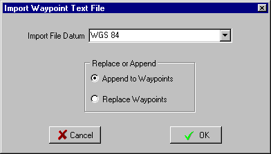
The datum used for importing (the datum used for the positions in the file) can be specified, if the datum is in the file in one of OziExplorers standard datums then it will default to this.
Before manually creating your own text files for importing you should create some waypoints in OziExplorer and Export these to a file in the desired format and use this file as a template.
File Format
The format is the same as the Waypoint text files from Waypoint+ but with some extensions.
However these files are not meant for import by Waypoint+ there are extra options on the Garmin menu for importing and exporting Waypoint+ files. The reason Waypoint+ cannot use these files is the datum names are different, when Waypoint+ finds a datum name it does not recognize it gives an error.
RECORD TYPES
Waypoint+ types
The 1st field is signifies that it is a Waypoint record, the characters Waypoint or WP can be used.
Each keyword is followed by a designator that describes what kind of storage is used with latitude and longitude. DM and DMS are stored in as single packed floating point number.
D=decimal degrees; ddd.dddddddd (34.064531922)
DM=degrees minutes; ddd.mmmmmmm = ddd mm.mmmmmmm (34.06548 = 34 6.548')
DMS=degrees minutes seconds; ddd.mmsssssss = ddd mm ss.sssss (34.06453 = 34 6' 4.53")
UTM=zone,easting,northing
Extended Types
To make it easier for text data entry extra extended types have been added.
DMX=degrees minutes; the degrees and minutes are entered into their own fields separated by commas.
DMSX=degrees minutes seconds; the degrees, minutes are entered into their own field separated by commas.
BNG=zone,easting,northing (British National Grid)
IG=zone,easting,northing (Irish Grid)
NZG=easting,northing (New Zealand Grid)
SG=easting,northing (Swedish Grid)
SUI=easting, northing (Swiss grid)
WP, waypoint name, latitude, longitude, date , time , waypoint description.
Example:
Standard Waypoint+ types
WP, waypoint name, latitude, longitude, date , time , waypoint description.
The date must be in month/day/year format or left out and the current date will be used.
Examples:
WP,D,WPNAME,34.064531922,-117.2959507350,11/23/1995,19:29:00,Description
WP,DM,WPNAME,34.06548,-117.80632,11/23/1995,19:29:00,Description
WP,DMS,WPNAME,34.06453,-117.29595,11/23/1995,19:29:00,Description
WP,UTM,WPNAME,56J,445946,7063980,11/23/1995,19:29:00,Description
Extended Types (preferred for manual data entry)
WP, waypoint name, latitude(multiple fields), longitude(multiple fields), date , time , waypoint description.
Examples:
WP,DMX,WPNAME,34,6.548,-117,80.632,11/23/1995,19:29:00,Description,Symbol
WP,DMSX,WPNAME,34,6,4.53,-117,29,5.95,11/23/1995,19:29:00,Description,Symbol
No fields are case sensitive, lowercase or mixed case can be used in any field.
The symbol is coded as A=0 B=1 C=2 etc
The Garmin GPS waypoint display format is also added to the end of the line after the symbol, however it is not guaranteed that this will be continued in future. N = Name S = Symbol C = Comment
Datum
The datum can be specified in the file.
The Datum Record Type
DATUM,WGS 84
The datum is optional, if it is not there you will be requested for the datum.
The datum must be a recognized OziExplorer datum name, these can be viewed on the datum list.
When importing the file the software will allow you to modify the datum.
Anonimus
–Ф—А—Г–≥–Є–µ —Б—В–∞—В—М–Є –Є–Ј —Н—В–Њ–≥–Њ —А–∞–Ј–і–µ–ї–∞
GPSMAP 276C –∞–≤—В–Њ—А –§–Њ—А–Њc–µ–љ¬©–Њ
–Ъ–∞–Ї–Є–µ —Б—Г—Й–µ—Б—В–≤—Г—О—В –Ї–∞—А—В—Л –і–ї—П GPS –љ–∞–≤–Є–≥–∞—Ж–Є–Є.
–Ъ–∞—А—В—Л –і–ї—П –У–∞—А–Љ–Є–љ —Б–≤–Њ–Є–Љ–Є —А—Г–Ї–∞–Љ–Є (—Г—А–Њ–Ї 1) –∞–≤—В–Њ—А –§–Њ—А–Њc–µ–љ¬©–Њ
–Э–∞—Б—В—А–Њ–є–Ї–∞ OziExplorer –∞–≤—В–Њ—А –§–Њ—А–Њc–µ–љ¬©–Њ
–Э–∞—З–∞–ї–Њ —А–∞–±–Њ—В—Л –∞–≤—В–Њ—А –§–Њ—А–Њc–µ–љ¬©–Њ
–†–µ–Ї–Њ–Љ–µ–љ–і–∞—Ж–Є–Є –њ–Њ –Ј–∞–њ–Є—Б–Є –Ґ—А—Н–Ї–∞ –Є –Ґ–Њ—З–µ–Ї –Љ–∞—А—И—А—Г—В–∞. –∞–≤—В–Њ—А –§–Њ—А–Њc–µ–љ¬©–Њ
